World Atlas: Burma (Myanmar). On this page you can see the map, country flag and many detailed information about the people, history and economy of Burma (Myanmar).
Here you can find online selected information about the geography, inhabitants, government, economy and history of Burma (Myanmar). Included are selected statistics, an overview map and the detailed map of Burma (Myanmar). But let's start with the flag of Burma (Myanmar) here:
Burma (Myanmar) - Overview:
What you should know about Burma (Myanmar)? Let's start with this: Various ethnic Burmese and ethnic minority city-states or kingdoms occupied the present borders through the 19th century. Over a period of 62 years (1824-1886), Britain conquered Burma and incorporated the country into its Indian Empire. Burma was administered as a province of India until 1937 when it became a separate, self-governing colony; in 1948, Burma attained independence from the British Commonwealth. Gen. NE WIN dominated the government from 1962 to 1988, first as military ruler, then as self-appointed president, and later as political kingpin. In response to widespread civil unrest, NE WIN resigned in 1988, but within months the military crushed student-led protests and took power. Multiparty legislative elections in 1990 resulted in the main opposition party - the National League for Democracy (NLD) - winning a landslide victory. Instead of handing over power, the junta placed NLD leader (and 1991 Nobel Peace Prize recipient) AUNG SAN SUU KYI under house arrest from 1989 to 1995, 2000 to 2002, and from May 2003 to November 2010. In late September 2007, the ruling junta brutally suppressed protests over increased fuel prices led by prodemocracy activists and Buddhist monks, killing an unknown number of people and arresting thousands for participating in the demonstrations. In early May 2008, Burma was struck by Cyclone Nargis, which left over 138,000 dead and tens of thousands injured and homeless. Despite this tragedy, the junta proceeded with its May constitutional referendum, the first vote in Burma since 1990. Legislative elections held in November 2010, which the NLD boycotted and were considered flawed by many in the international community, saw the ruling Union Solidarity and Development Party garner over 75% of the contested seats. The national legislature convened in January 2011 and selected former Prime Minister Thein SEIN as president. Although the vast majority of national-level appointees named by Thein SEIN were former or current military officers, the government initiated a series of political and economic reforms leading to a substantial opening of the long-isolated country. These reforms included releasing hundreds of political prisoners, signing a nationwide cease-fire with several of the country's ethnic armed groups, pursuing legal reform, and gradually reducing restrictions on freedom of the press, association, and civil society. At least due in part to these reforms, AUNG SAN SUU KYI was elected to the national legislature in April 2012 and became chair of the Committee for Rule of Law and Tranquility. Burma served as chair of the Association of Southeast Asian Nations (Asean) for 2014. In a flawed but largely credible national legislative election in November 2015 featuring more than 90 political parties, the NLD again won a landslide victory. Using its overwhelming majority in both houses of parliament, the NLD elected HTIN KYAW, AUNG SAN SUU KYI’s confidant and long-time NLD supporter, as president. Burma's first credibly elected civilian government after more than five decades of military dictatorship was sworn into office on 30 March 2016.
Geography of Burma (Myanmar)
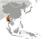 Where on the globe is Burma (Myanmar)? The location of this country is Southeastern Asia, bordering the Andaman Sea and the Bay of Bengal, between Bangladesh and Thailand. Total area of Burma (Myanmar) is 676,578 sq km, of which 653,508 sq km is land. So this is quite a large country. How could we describe the terrain of the country? This way: central lowlands ringed by steep, rugged highlands. The lowest point of Burma (Myanmar) is Andaman Sea/Bay of Bengal 0 m, the highest point Gamlang Razi 5,870 m. And the climate is tropical monsoon; cloudy, rainy, hot, humid summers (southwest monsoon, June to September); less cloudy, scant rainfall, mild temperatures, lower humidity during winter (northeast monsoon, December to April).
Inhabitants of Burma (Myanmar)
Let's take a look how many people live in Burma (Myanmar). The number is: 55,123,814. So quite a lot people live here. Who lives here? Burman (Bamar) 68%, Shan 9%, Karen 7%, Rakhine 4%, Chinese 3%, Indian 2%, Mon 2%, other 5%. What are the languages in Burma (Myanmar)? Burmese (official). And the religions: Buddhist 87.9%, Christian 6.2%, Muslim 4.3%, Animist 0.8%, Hindu 0.5%, other 0.2%, none 0.1%. How old are the people in average? 28.2 years. We have to add that this number is the median - so one half of the people is older than this, one half is younger. And what is their life expectancy (at birth)? This: 68.2 years. Where the people live in Burma (Myanmar)? Here: population concentrated along coastal areas and in general proximity to the shores of the Irrawaddy River; the extreme north is relatively underpopulated. The major urban areas of Burma (Myanmar) are: Rangoon (Yangon) (capital) 4.802 million; Mandalay 1.167 million; Nay Pyi Taw 1.03 million (2015).
Government and Economy of Burma (Myanmar)
The capital of Burma (Myanmar) is Rangoon (Yangon); note - Nay Pyi Taw is the administrative capital and the government type parliamentary republic. Let's take a look at the administrative divisions - 7 regions (taing-myar, singular - taing), 7 states (pyi ne-myar, singular - pyi ne), 1 union territory. Regarding the economy of Burma (Myanmar), important industrial products are agricultural processing; wood and wood products; copper, tin, tungsten, iron; cement, construction materials; pharmaceuticals; fertilizer; oil and natural gas; garments; jade and gems. Important agricultural products are rice, pulses, beans, sesame, groundnuts; sugarcane; fish and fish products; hardwood. The most important export commodities are natural gas; wood products; pulses and beans; fish; rice; clothing; minerals, including jade and gems and the most important export partners are China 40.6%, Thailand 19.1%, India 8.8%, Singapore 7.6%, Japan 5.7% (2016). The most important import commodities are fabric; petroleum products; fertilizer; plastics; machinery; transport equipment; cement, construction materials; food products? edible oil and the most important import partners are China 33.9%, Singapore 14.3%, Thailand 12.5%, Japan 7.9%, India 6.9%, Malaysia 4.3% (2016). How rich is Burma (Myanmar) and how rich are people in this country? The most important number here is GDP per capita (PPP): $6,300 (2017 est.). This is quite a low number. Let's add that this means Gross Domestic Product per person, which is recalculated with respect to the relative cost of local goods and services. And one more important number - population below poverty line: 25.6% (2016 est.).